Location & Connectivity
TVS Emerald Rayasandra Location
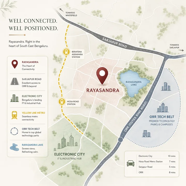
TVS Emerald Rayasandra occupies a 7.18-acre lake-adjacent site at Rayasandra in South-East Bengaluru - a locality that sits, uniquely, on the dual-corridor spine between two of the city's most important employment engines: Sarjapur Road and Electronic City. Off the Hosa Road / Hosur Road axis, with Electronic City roughly 4 km away and the Namma Metro Yellow Line now operational through nearby stations, Rayasandra has moved from a quiet, road-dependent belt into one of South-East Bengaluru's genuinely connected residential micro-markets. This page works through the location in full - the corridor logic, road and metro connectivity, employment nodes, schools, hospitals, retail, and the lake that defines the site. For location reading, TVS Emerald RR Nagar keeps the context local: commute anchors, school access, hospital reach, retail convenience, and last-mile movement decide whether the address works.
Where It Sits
Rayasandra, South-East Bengaluru
Rayasandra lies in South-East Bengaluru, in the pocket bounded by Hosur Road (NH-44) to the west, Sarjapur Road to the north-east, and Electronic City to the south-west. Its defining locational feature is dual-corridor access: a resident can head toward Electronic City's IT campuses in one direction, or toward the Sarjapur Road and Outer Ring Road tech belt in the other, without being funnelled through a single congested artery. In a city where commute pain is largely a function of being trapped on one overloaded road, that optionality is a structural advantage.
The site itself sits alongside Rayasandra Lake, giving it a permanently open edge, a cooler microclimate, and a low-density boundary that road-fronting projects cannot match.
Road Connectivity
Connected to Both Corridors
Rayasandra's road network connects it to both of its anchoring corridors and, through them, to the wider city.
| Destination | Approx. distance |
|---|---|
| Electronic City (Phase 1 IT hub) | ~4 km |
| Hosa Road (arterial link to Hosur Rd ↔ Sarjapur Rd) | ~2 - 5 km |
| Sarjapur Road (main junction) | ~6 - 8 km |
| Bellandur / ORR tech belt (via Hosa Rd) | ~11 km |
| HSR Layout | ~9 - 11 km |
| Silk Board junction | ~12 - 14 km |
| Outer Ring Road (Central Silk Board - KR Puram belt) | ~10 - 12 km |
| Bangalore City Railway Station | ~22 - 25 km |
| Kempegowda International Airport | ~48 - 55 km |
Hosa Road is the local arterial that stitches Rayasandra to both corridors - linking down to Hosur Road (NH-44) and across toward Sarjapur Road. Hosur Road / NH-44 is the primary spine to Electronic City and, southward, to Hosur and the Tamil Nadu border industrial belt; northward it feeds Silk Board and the Outer Ring Road. Sarjapur Road, reachable in the other direction, is one of Bengaluru's fastest-growing office and residential corridors, home to Wipro's Sarjapur campus, the Decathlon-RGA belt, and a dense cluster of IT and start-up offices. The distances above are approximate, drawn from portal locality data; actual drive times vary with traffic.
Metro Connectivity
Namma Metro Yellow Line - Operational
The single biggest connectivity upgrade for this corridor is the Namma Metro Yellow Line, which runs from RV Road to Bommasandra via Silk Board and Electronic City and is now operational. It brings rail connectivity within a short drive of Rayasandra.
| Metro station (Yellow Line) | Approx. distance |
|---|---|
| Beratena Agrahara | ~3 km |
| Hosa Road | ~5 km |
| Electronic City I / Electronic City | ~4 - 6 km |
The relevant stations for a Rayasandra resident are Hosa Road, Beratena Agrahara, and the Electronic City stations - all on the operational Yellow Line spine. This is a meaningful distinction from corridors that are still banking on future rail: the Yellow Line here is live, connecting Electronic City and the South-East belt to Silk Board and, via interchange, the wider metro network. For daily commuters to Electronic City or the central business district, that live rail option materially reduces road dependence. (Note: some marketing material references a "Singasandra" metro station - Singasandra is not a named Yellow Line stop; the correct nearby stations are Hosa Road, Beratena Agrahara and Electronic City.)
Employment Nodes
Two of Bengaluru's Largest Job Clusters
Rayasandra's location case is fundamentally an employment case: it sits within easy reach of two of Bengaluru's largest job clusters.
| Employment hub | Approx. distance |
|---|---|
| Electronic City (Infosys, Wipro, TCS, HCL campuses) | ~4 km |
| Wipro Electronic City campus | ~5 - 6 km |
| Sarjapur Road IT offices (Wipro Sarjapur, Decathlon belt) | ~7 - 9 km |
| RGA Tech Park (Sarjapur - ORR) | ~9 - 11 km |
| ORR tech belt (Bellandur / Ecospace / RMZ) | ~11 - 14 km |
Electronic City, roughly 4 km away, is Bengaluru's original and largest IT hub - home to Infosys, Wipro, TCS, HCL and hundreds of other technology employers across Phases 1 and 2. That proximity is the anchor of Rayasandra's residential demand: for the tens of thousands who work in Electronic City, a lake-edge branded community 4 km from the office is a compelling proposition. Layered on top is access to the Sarjapur Road and ORR employment belt - Wipro Sarjapur, the RGA Tech Park, and the Bellandur / Ecospace / RMZ cluster - reachable via Hosa Road. Few South-East residential locations offer this dual reach.
Schools
Schools Nearby
The Rayasandra and Off-Sarjapur belt is well-served by schools across the mid-premium to premium band.
| School | Approx. distance |
|---|---|
| New Age Public School, Rayasandra | ~1 - 2 km |
| New Cambridge Public School | ~2 - 3 km |
| Mount Carmel School | ~3 - 4 km |
| VIBGYOR High (Electronic City) | ~5 - 7 km |
| Gaudium / Ekya / Oakridge (Sarjapur belt) | ~8 - 12 km |
For families, the immediate presence of New Age Public School and New Cambridge Public School within a few kilometres, plus access to the premium Sarjapur-belt international schools (Gaudium, Ekya, Oakridge) and VIBGYOR High at Electronic City, means the full spectrum of schooling - from neighbourhood to international-curriculum - is within a reasonable radius.
Hospitals
Healthcare Access
Healthcare access spans neighbourhood clinics and major multi-speciality hospitals.
| Hospital | Approx. distance |
|---|---|
| Springleaf Hospital | ~2 - 4 km |
| Anugraha Hospital | ~2 - 4 km |
| Sri Sai Ram / Mathru Hospital | ~2 - 5 km |
| Kauvery Hospital (Electronic City) | ~5 - 6 km |
| Mazumdar Shaw / Narayana Health City (Bommasandra) | ~7 - 9 km |
The standout is Narayana Health City / Mazumdar Shaw at Bommasandra, one of South India's largest tertiary-care and cardiac-care complexes, roughly 7-9 km away, alongside Kauvery Hospital at Electronic City and several neighbourhood hospitals within a few kilometres. For a South-East location, that is strong healthcare depth.
Retail & Recreation
A Green-and-Blue Pocket
| Landmark | Approx. distance |
|---|---|
| Rayasandra Lake | adjacent / <1 km |
| M5 Ecity Mall / SBR Lucky Mall / Metro Mall | ~3 - 6 km |
| Huskur Lake View Point | ~4.5 km |
| Muthanallur Lake | ~9.4 km |
Day-to-day retail is served by the Electronic City mall cluster (M5 Ecity, SBR Lucky Mall) 3-6 km away, with the Sarjapur Road retail belt reachable in the other direction. The recreation story, though, is defined by water: Rayasandra Lake sits adjacent to the site, with the Huskur Lake View Point and Muthanallur Lake also within easy reach - a green-and-blue pocket unusual for a corridor this well-connected.
The Defining Landmark
Rayasandra Lake - the Defining Landmark
The most important landmark for TVS Emerald Rayasandra is not a road, a mall, or an office park - it is Rayasandra Lake, immediately adjacent to the site. In a densifying South-East corridor, a lake edge is one of the few attributes that cannot be replicated by the next project down the road. It fixes one boundary of the community as permanently open, moderates the microclimate, and gives the development a naturally low-density edge. For lake-facing units, the outlook is protected for the life of the building. It is the single feature that most distinguishes this site from the road-fronting alternatives across the corridor.
The Location Verdict
Dual-Corridor, Metro, Lake Edge
TVS Emerald Rayasandra's location proposition is, in short: dual-corridor employment access, an operational metro spine, and a scarce lake edge. It sits ~4 km from Electronic City, within reach of the Sarjapur Road and ORR belts, a short drive from live Yellow Line stations, and alongside a lake - a combination few South-East Bengaluru micro-markets can match. The honest trade-off is distance from the airport (~48-55 km) and the city's central and northern business districts, which makes this a location best suited to households anchored in the South-East IT economy rather than the airport or central-Bengaluru economy.
For buyers weighing the corridor, Rayasandra sits within a cluster of branded South-East Bengaluru launches worth benchmarking side by side on connectivity, configuration and price.
To assess the location in person, request a site visit through the contact form. The overview page sets out the full project; the price page works through the micro-market pricing view; and the amenities and master-plan pages detail how the community makes use of its lake-edge, dual-corridor site.
Location Questions
TVS Emerald Rayasandra Location - FAQ
Where exactly is TVS Emerald Rayasandra located?
At Rayasandra in South-East Bengaluru, in the pocket bounded by Hosur Road (NH-44) to the west, Sarjapur Road to the north-east, and Electronic City to the south-west. The 7.18-acre site sits alongside Rayasandra Lake, off the Hosa Road / Hosur Road axis, giving it a permanently open, low-density edge that road-fronting projects cannot match.
How far is TVS Emerald Rayasandra from Electronic City?
Approximately 4 km. Electronic City is Bengaluru's original and largest IT hub - home to Infosys, Wipro, TCS, HCL and hundreds of other employers across Phases 1 and 2 - and that proximity is the anchor of Rayasandra's residential demand. The Sarjapur Road and ORR employment belt is also reachable via Hosa Road.
What is the metro connectivity from TVS Emerald Rayasandra?
The Namma Metro Yellow Line (RV Road to Bommasandra via Silk Board and Electronic City) is operational, and its Hosa Road, Beratena Agrahara and Electronic City stations are within a short drive - Beratena Agrahara roughly 3 km and Hosa Road roughly 5 km away. Note that some marketing references a 'Singasandra' metro station, which is not a named Yellow Line stop; the correct nearby stations are Hosa Road, Beratena Agrahara and Electronic City.
What does dual-corridor access mean here?
It means a resident can head toward Electronic City's IT campuses in one direction, or toward the Sarjapur Road and Outer Ring Road tech belt in the other, without being funnelled through a single congested artery. In a city where commute pain is largely a function of being trapped on one overloaded road, that optionality is a structural advantage.
Which schools and hospitals are near TVS Emerald Rayasandra?
Schools include New Age Public School and New Cambridge Public School within a few kilometres, plus VIBGYOR High at Electronic City and the premium Sarjapur-belt international schools (Gaudium, Ekya, Oakridge). For healthcare, Narayana Health City / Mazumdar Shaw at Bommasandra - one of South India's largest tertiary-care complexes - is roughly 7-9 km away, alongside Kauvery Hospital at Electronic City and several neighbourhood hospitals within a few kilometres.
What is the location trade-off at TVS Emerald Rayasandra?
The strengths are dual-corridor employment access, an operational metro spine, and a scarce lake edge. The honest trade-off is distance from Kempegowda International Airport (~48-55 km) and the city's central and northern business districts, which makes this a location best suited to households anchored in the South-East IT economy rather than the airport or central-Bengaluru economy.